Cutting-Edge Technology
Near Surface Geology and Thermochronology
Supported by the cutting-edge trace & major element mapping, U-Th-Sm/He, U-Pb, and fission track geochronology facilities at the University of Calgary; delegates would learn about these techniques while exploring the data from this world class research facility and team.
Image credit: University of Calgary Geochronology Lab
Machine Language and Working with Big Geoscience Data
Machine language applications to geoscience will be presented in this short course. Here the basic principles of machine learning will be introduced, then best practices for applying machine learning to geoscience datasets for applications to mineral exploration, petroleum, critical zone science, paleontology and other geoscience challenges.
Geological Modeling of Outcrops with Unmanned Aerial Vehicles (UAV)
This short course could explore the rapidly growing scientific teaching and research tool, such as the application of 3-D models and 4k video created by UAVs. Measurement of geological features, reservoir characteristics, statistics on bed lengths and detailed sedimentology are now possible. This course would include a summary of licensing requirements and aviation protocol; along with safety protocols, tips and tools, appropriate software and processing the data and images.
Image credit: M Maracle
Global Navigation Satellite System-Interferometric Reflectometry (GNSS-IR)
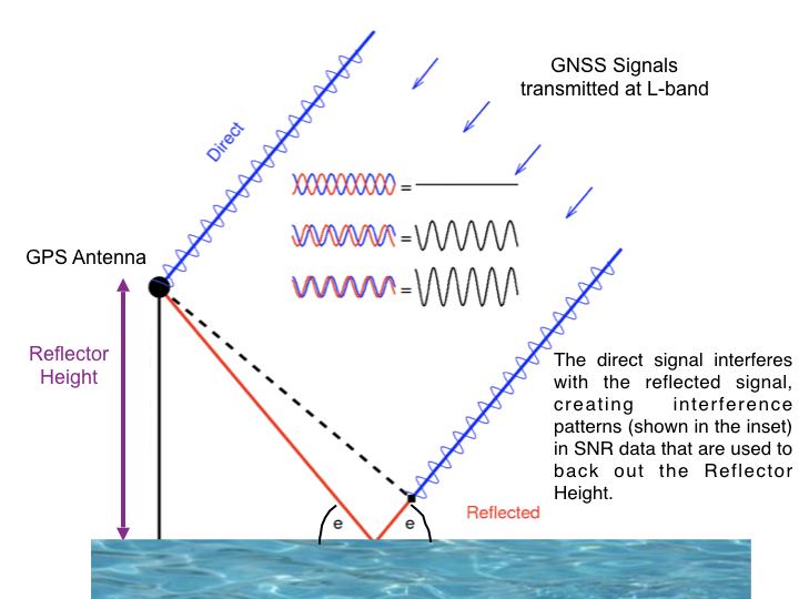
Reflected satellite signals around GNSS receivers used to be considered as interference when using GNSS for navigation. Today, these reflected waves have many exciting applications for environmental monitoring such as use as tidal gauges, monitoring vegetation growth and snow accumulation and soil moisture. As discovered during the Plate Boundary Observatory component of the US EarthScope program, these GNSS-IR applications complement regular use of GNSS arrays to monitor the impacts of droughts or hurricane water loads while also monitoring plate tectonic movement. Here delegates would be introduced to the precision and accuracy of GNSS-IR, then the strengths and weaknesses of these applications to environmental monitoring. In preparation for this workshop, participants would install the gnssrefl software in order to learn how to download GNSS data from global archives and then analyze this data for those environmental monitoring applications.
Image credit: gnssrefl


